 |
Like guardian angels, the GOES spacecraft keep a constant vigil over us. They're always on the job, bringing weather data that can predict a beautiful weekend for a picnic, or the potential strike of a terrifying hurricane. The latest GOES satellite, GOES-N, is being prepared for launch from Cape Canaveral Air Force Station in Florida, today, May 4, at 22:20 GMT (6:20 pm EDT. After launch and checkout, the new satellite will be stored as an in-orbit spare and remain ready to join the other operational satellites operated by the National Oceanic and Atmospheric Administration (NOAA). The GOES - or Geostationary Operational Environmental Satellites - are a joint effort between NASA and NOAA. The data delivered as a result of this partnership is seen on TV screens daily by millions of people in homes across the country. "The GOES environmental satellite data is a basic element of U.S. weather monitoring and forecast operations, and is used by meteorologists to update the public of the changes in our daily weather," says the NASA GOES Deputy Project Manager Andre Dress. "This vital information is constantly streaming down, 24 hours a day, 365 days a year." And while knowing whether to take your umbrella as you leave for work can be helpful, predicting violent weather systems like hurricanes takes on even greater importance. "The GOES satellites can see approaching storms which enable the proper authorities to issue warnings and to manage resources in an effort to minimize the potential harm to people and property," says Dress. NOAA's goal is to have two GOES satellites - known as GOES-East and GOES-West - operating at all times. Combined, the two satellites provide continuous data while covering 60 percent of the Earth''s surface, including the continental Untied States. The new series of satellites, which begins with the GOES-N spacecraft, is scheduled to replace the aging current geosynchonous satellites and employs improved on-board technology for more accurate weather prediction. Having an in-orbit replacement satellite "on station storage" means the GOES constellation recovery time can be measured in increments of days, rather than the years it would take to prepare and launch a satellite stored on the Earth. That time difference would be especially crucial if a GOES satellite failed during the peak of the hurricane season. Although constant weather monitoring has the most direct affect on our daily life, these satellites serve other important needs as well. The GOES satellites also provide instantaneous relay of distress signals from people, aircraft, or marine vessels to the search and rescue ground stations of the Search and Rescue Satellite Aided Tracking (SARSAT) System. A dedicated search and rescue transponder on board GOES is designed to detect emergency distress signals originating from Earth-based sources. These unique identification signals are normally combined with signals received by NOAA's Polar Operational Environmental Satellite system and relayed to a search and rescue ground terminal. The combined data are used to perform effective search and rescue operations. These satellites also contribute to worldwide environmental monitoring, help with solar environment disturbance detection and provide data scientists use to understand the atmosphere. GOES-N is scheduled for an early summer 2005 liftoff aboard the new Boeing Delta IV rocket. With the Delta IV's two solid rocket boosters, the Launch Vehicle will insert the satellite into an orbit that will allow the spacecraft to save fuel and provide NOAA with an expected lifespan, in space, in excess of 10 years. After NASA completes the satellite's launch and in-orbit checkout, NOAA will take over its day-to-day operation in order to maintain an unblinking vigil from the sky. Related Links NOAA Geostationary Satellite Server GOES Project Science SinoDaily Search SinoDaily Subscribe To SinoDaily Express 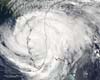 Paris (AFP) Apr 20, 2005
British scientists say they have devised the first accurate tool to predict the severity of the US hurricane season, an innovation that could help save lives and cut costs for the insurance industry. |
|